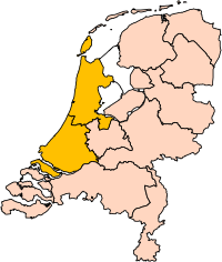
Holland position


Forfatter/Opretter:
Centraal Bureau voor de Statistiek
Kredit:
Centraal Bureau voor de Statistiek
størrelse:
200 x 236 Pixel (161211 Bytes)
beskrivelse:
Edit to User:Mtcv's Image:Noord-Holland position.svg to show North and South Holland together.
Licens:
Attribution
Kommentar på licensen:
© Indehaveren af ophavsretten til denne fil, Centraal Bureau voor de Statistiek, tillader enhver at bruge filen til ethvert formål, under betingelse af, at rettighedshaveren krediteres som påkrævet. Videredistribution, afledte værker, kommerciel brug og alle andre formål tillades.

This image is (in part or entirely) based on geographical data from Statistics Netherlands (Centraal Bureau voor de Statistiek). Digital geometry files in ESRI format can be downloaded from their website [1].

In particular, boundary data of statistical districts is based on either the Wijk- en buurtkaart 2005, or the Wijk- en buurtkaart 2003 ("CBS/TOPgrenzen"). Data on localities (bevolkingskernen) are from the publication Bevolkingskernen in Nederland 2001.

Conditions of use (in Dutch):

  • Bij visualisering van gegevens met behulp van het digitale bestand Wijk- en buurtkaart 2005 dient te worden vermeld:
Bron: © 2006, Centraal Bureau voor de Statistiek / Topografische Dienst Kadaster
  • Bij visualisering van gegevens met behulp van het digitale bestand CBS/TOPgrenzen dient te worden vermeld:
Grenzen ondergrond: © 2003, Centraal Bureau voor de Statistiek/Topografische Dienst Kadaster
  • Bij visualisering van gegevens met behulp van het digitale bestand "Bevolkingskernen 2001" dient te worden vermeld:
Bron: © 2005, Centraal Bureau voor de Statistiek

Unless otherwise specified, data on waterways and lakes are from the public domain Digital Chart of the World.


Yderligere oplysninger om licens til billedet kan findes her. Sidste ændring: Mon, 30 Dec 2024 18:40:30 GMT