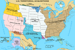
U.S. Territorial Acquisitions
Forfatter/Opretter:
United States federal government
| Dette er et retoucheret billede, hvilket betyder, at det er blevet digitalt ændret fra sin oprindelige version. Ændringer: {{{1}}}. Ændringer blev udført af en:User:pink and White.
|
Shortlink:
kilde:
størrelse:
1536 x 1038 Pixel (1164091 Bytes)
beskrivelse:
The Territorial acquisitions of the United States, such as the Thirteen Colonies, the Louisiana Purchase, the Oregon Country, the Mexican Cession, and so on.
Licens:
Public domain
Kommentar på licensen:
This map was obtained from an edition of the National Atlas of the United States. Like almost all works of the U.S. federal government, works from the National Atlas are in the public domain in the United States.
Online access: NationalAtlas.gov | 1970 print edition: Library of Congress, Perry-Castañeda Library
Online access: NationalAtlas.gov | 1970 print edition: Library of Congress, Perry-Castañeda Library
Yderligere oplysninger om licens til billedet kan findes her. Sidste ændring: Wed, 30 Apr 2025 17:20:41 GMT
